All filters
Nepal Down Arrow
Nepal Trekking Down Arrow

Laya Gasa Trek

Bhutan
Hotel / Tea House / Tent
Laya Gasa Trek
Location Icon
Destination
Bhutan
Hiking Person Icon
Activity
Bhutan Trekking
Calender Clock Icon
Duration
19 Days
Mountain Icon
Max. Altitude
4080M
Group Icon
Group Size
2-16
Cloud Icon
Best Season
March-May & Sept-Nov
Taco Icon
Grade
Strenuous
House Icon
Accommodation
Hotel / Tea House / Tent
Food Icon
Meals Included
Yes

Trip Overview

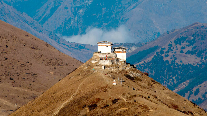
The Laya Gasa trek is considered the most scenic trek in Bhutan. The circuit offers a panoramic view of the country's pristine and unspoiled natural landscapes. The trek lasts fourteen days and covers a distance of 217 km from the village of Gunitsawa to Gasa.

Discover alpine meadows, high mountains, and dense subtropical jungles throughout this adventure. The first five days of the trek follow the same route as the Jomolhari I trek through the Jidme Singye National Park. This first stage reveals beautiful views of the Jomolhari, Jichu, Drake, and Tsherimgang mountains. On the sixth day, the trail diverges towards Lingshi, to reach the camp set up at Chebisa, a charming village adorned with a crystal-clear waterfall.

Along the trail, you will have the opportunity to observe the endemic animals of the region, such as the blue sheep or the Takin, the national animal of Bhutan. You will pass through mountain villages populated by the Layaps (the people of Laya). This ethnic group stands out in Bhutanese society because of its culture, traditions, and atypical appearance. The hike also offers a relaxing day in the famous Gasa hot springs to regain your energy.

The Laya Gasa trek is a fairly difficult trek among Bhutan trekking circuits due to the high altitude trails that alternate between steep climbs and descents. The best times to undertake this challenge are between April and June and mid-September to mid-November.

Highlights of the Laya Gasa Trek

  • Jomolhari trekking, one of the most beautiful routes in the world
  • Full day in Laya village to discover the traditional Layap way of life
  • The climb to Taktsang Monastery, the Tiger's Nest
  • The main dzongs of the country: Thimphu and Punakha
  • The variety of landscapes: forests, majestic valleys, crops, snow-capped peaks

Itinerary

Day 01: Arrival in Kathmandu
Arrive in Kathmandu, Tribhuvan International airport, Transfer to Hotel in Kathmandu, Check in Hotel, Briefing about Package tour.
Day 02: Kathmandu City Tour
After breakfast full day (6-7 Hrs) world heritage city sightseeing of Kathmandu (Visit: Pashupatinath Temple – Hindu temple which 4 km east from the downtown. Bouddhanath Stupa – The largest Buddhist stupa in South Asia which is 2km drive to north from Pashupatinath temple. Swayambhunath Stupa – The oldest Buddhist stupa which is on the hilltop, also known as Monkey Temple is 3 Km west from Kathmandu downtown. Kathmandu Durbar Square – The old Royal Palace was build on the reign of Mall King (15th -17th Century), Living goddess Kumari House with many more monuments.
Day 03: Fly to Paro
Morning journey to Paro. If the weather is clear, this trip will provide a chance to appreciate the stunning vistas of the snow-covered and sharp-edged Himalayan mountains.
Day 04: Paro
The Paro Valley encompasses a rich culture, stunning landscapes, and hundreds of myths and legends. It is home to the country's oldest temples and monasteries, the national museum, and the kingdom's only international airport. Mount Jomolhari (7,314m) reigns in the north of the valley, and its glacial water plunges through deep gorges to form Pa Chhu (the Paro River). Paro is also one of the most fertile valleys in Bhutan, producing a significant portion of the local red rice on its terraced fields. The flight to Paro is one of the most spectacular air experiences in the world. During the landing or takeoff, one can see Mt. Everest, Kanchenjunga, Makula, and other high peaks such as Jomolhari, Jichu Drakey, and Tsrim Gang. You will be greeted by a guide representing Exquisite Bhutan. Check-in at the hotel, have some free time to freshen up and stretch your legs, then visit the National Museum, the Runpung Dzong, and a quick city tour.
Day 05: The trek starts from the village of Gunitsawa
After a fairly early breakfast, drive to the village of Day 05: Sharna Zampa - Thangthangkha (he trek starts from theGunitsawa and its military outpost where you will be asked to present the trekking permit that we will have issued to you. Short walk to Sharna Zampa across the river.
Day 06: Sharna Zampa - Thangthangkha (Spectacular view of Mount Jomolhari)
During this long day, the trail sees many moderate climbs and a few false flats. One last nice climb and the valley will be reduced to a small path that descends to a meadow where you will set up camp for the night. From this point, if the weather permits, you will enjoy a superb view of Mt. Jomolhari . Elevation gain: 770 m, descent: 10 m, camp altitude: 3,610 m.
Day 07: Thangthangkha - Jangothang (Jangothang, one of the most beautiful camps in the Himalayas)
Today, we continue the hike in the Paro Chhu valley which extends over a vast alpine meadow, in the heart of a large forest. In this part of the region, yaks and shepherds' huts redraw the landscape to give it an atypical character. We then visit the villages of Soe, Takethang and Dangochang. Arrived at Jangothang, one of the most beautiful campsites in the Himalayas, enjoy once again a spectacular view of Mount Jomolhari. Elevation gain: 480 m; campsite altitude: 4080 m
Day 08: Find a blue sheep on the heights of the valley
Spending a day of rest in Jangothang allows us to make many visits, while discovering the landscapes punctuated by lakes and snow-capped mountains, such as Jomolhari and Jichu Drake. Jangothang is also the ideal place to acclimatize. Take advantage of this stopover to go to Tosoh or walk around the surrounding area.
Day 09: Jangothang - Lingshi (Long day of hiking)
Today is one of our longest days of walking. We cross the Nyilila Pass at 4,870 m and take the opportunity to observe the blue sheep grazing on the mountain slopes. After lunch, we continue our hike to Lingshi, a beautiful U-shaped valley. On a clear day, the view of Lingshi Dzong is breathtaking. The campsite is located right next to a stone hut, before passing Lingshi Dzong . Ascent: 840 m; Descent: 870 m; Campsite altitude: 4010 m
Day 10: Lingshi - Chebisa (Admire the flocks of blue sheep on the Lingshi ridge)
Today, the hike will be shorter. We quickly reach a chorten under the Lingshi dzong. For this route, you have the choice between taking the main track or going around the Lingshi dzong which is located at the top of the ridge (4,220 m). After passing the Lingshi dzong, we cross the villages of Lingshi and Goyul. The camp is in Chebisa where we will have plenty of time to rest in the villagers' houses. Behind the village, a beautiful waterfall is worth a look. Ascent: 280 m; descent: 410 m; campsite altitude: 3880 m
Day 11: Chebisa - Shomuthang (A long climb behind the village of Chebisa)
The morning begins with a long climb (2-3 hours) behind the village of Chebisa. We explore a vast pasture towards the Gobu La Strait. After crossing Gobu La (4,410 m), we descend into the valley, then again survey a small climb before descending at our own pace the slope leading to Shakshepasa (3,980 m), another U-shaped valley. Continuing our descent, we finally reach the Shomuthang campsite, above a tributary of the Nochu River. Ascent: 890 m; Descent: 540 m; Campsite altitude: 4220 m
Day 12: Shomuthang - Robluthang (Superb viewpoint on the Tiger Mountain)
We begin our tour of the day by walking through the valley towards Kang Bum (6,226 m) and its beautiful edelweiss. After two hours of climbing, we arrive at Jhari La (4,750 m), from where we can see Sinche La, the strait to be tamed the next day. The great snow peak to the north is called Gangchhenta (6,840 m), better known as Tiger Mountain. The camp near the river is called Tsheri Jathang, nestled in a remote valley. Ascent: 700 m; descent: 760 m; campsite altitude: 4160 m
Day 13: Robluthang - Limithang (Some landscapes of lateral moraines)
The trek begins with an initial ascent lasting 40 to 60 minutes, followed by a gradual climb of an hour and a half through a rock field. We therefore climb for about an hour before reaching Sinche La (5,005 m) — the final pass and highest point of the route (if you do not intend to continue the Snowman trek from Laya). As we descend, an impressive moraine and a glacial lake at the foot of the valley are revealed. You will have the chance to admire some classic examples of lateral moraines, where the glacier has pushed the rocks on both sides of the valley. Above the moraine, we cross the Kango Chhu to reach the campsite of Limithang. The summit of Gangchhenta is opposite the campsite. Ascent: 850 m; Descent: 870 m; Camp altitude: 4,140 m.
Day 14: Limithang - Laya (Trail to the west side of Laya village)
Today's descent follows a narrow, winding river valley. The trail takes you to the west side of the village of Laya, which has a community school and a basic health unit with a telephone line in its centre. The campsite is located below the school. Ascent: 60 m; descent: 340 m; campsite altitude: 3840 m
Day 15: Laya - Koina (Through the Mo Chhu River Valley)
The trail follows a descent along the valley belonging to the Mo Chhu River. We avoid the rough natural passages, while capturing the breathtaking views of the torrential river, streams and waterfalls. We pass through slopes and descents to Kohi Lapcha at 3,300 m. The trek ends at the Koina Chhu River where we set up our campsite. Ascent: 260 m; Descent: 1,070 m; Campsite altitude: 3,050 m
Day 16: Koina - Gasa (Last major ascent of Laya Gasa)
Today's trek offers the biggest climb of the Laya Gasa Trek. We cross Bari La (3,740 m) and descend to Gasa village (2,770 m). There is a campsite near Gasa dzong. You can choose to stay in the village or descend to the Gasa Tsachu hot springs, an hour's drive away, to relax in its mineral waters. This is one of the most popular hot springs in Bhutan. Ascent: 740 m; Descent: 1,500 m; Campsite altitude: 2,240 m
Day 17: From Gasa to Punakha
After breakfast, we drive to Punakha , the ancient capital of Bhutan. The Punakha Valley is a relatively warm, almost tropical region. We visit its Dzong and the nearby suspension bridge if time permits.
Day 18: From Punakha to Paro
After breakfast drive to Paro. Enroute stop at Thimphu for lunch, shopping etc. and continue to Paro in the afternoon
Day 19: Departure to onward destination
After breakfast, we drive to drop you at Paro airport.

Cost Include

  • All pickup and drop in Nepal
  • Accommodation in Kathmandu
  • Full day sightseeing in Kathmandu with English Speaking Guide.
  • Mixed accommodation in 3+ standard and Trekking in Home stay or Tent.
  • All 3 meals (Breakfast, Lunch and Dinner) inclusive in tourist standard restaurants and hotel
  • Transport/ new model,
  • Entrance fees to all Major Tourist Sites including museums, fortresses & Temples
  • Royalty of USD 200 per-night per head, TDF and Government tax
  • Professional Company English Speaking Guide
  • Mineral water on tour
  • Bhutan Visa fee (As separate above)
  • Traditional herb’s bath (As separate above)
  • Bhutan Cultural show (Private) for less than 15 persons in a group (Optional as separate above)

Cost Exclude

  • International Airfare
  • Travel Insurance
  • Beverages and Personal expenses
  • Monuments entrance fees at Kathmandu
  • Lunch and dinner at Kathmandu
  • Personal tips to staffs

Equipment list for Laya Gasa Trek

This checklist is designed to help you prepare for a trekking holiday in Nepal, with additional notes for those attempting to summit a trekking peak. It's reassuring to know that high-quality gear, including outdoor clothing and sleeping bags, can be conveniently rented in Kathmandu.

Most treks will be in lodges or teahouses, which offer basic rooms with two single beds and mattresses. These lodges, with their cozy rooms and provided blankets, ensure a comfortable stay, making your trek a more enjoyable experience. A good-quality three-season sleeping bag should suffice. However, for trekking peaks, you'll generally set up base camp with tents, necessitating a warmer sleeping bag, a liner to enhance its warmth, and a sleeping mattress.

TRAVEL DOCUMENTS HEAD
Debit/Credit Cards Sun Cap
PP Size Photo (2 Pieces) Fleece Hat/ Warm Hat (1-2 Pcs)
Insurance Paper And Contact Address. Neck Gaiter (2 Pcs)
Family Members / Company’s Contact Head Lamp with extra batteries
Address Sun Glasses (UV Protection)
Travel Insurance Balaclava
   
HANDS AND FEET UPPER BODY
Light Liner & Down Gloves Thermal Top Base Layer (2 Pcs)
Normal Socks (5-6 Pairs) Fleece Jacket (1 Pcs)
Trekking Shoes  Gore Tex Jacket (1 Pcs)
Slipper (1 Pair) Down Jacket (1 Pcs)
Camp Shoes Quick Dry T-Shirt (2 Pcs)
Hiking Boot with ankle support Wind breaker/Windproof Jacket
   
LOWER BODY PERSONAL EQUIPMENT
Thermal Bottom Base Layer (2 Pcs) Down Sleeping Bag -10°C to -20°C
Fleece Trouser (1pcs) Headlamp (Rechargeable Batteries)
Gore Tex Pant (1 pcs) Trekking Pole
Light Weight Quick Dry Trekking Pants(2-3 Pairs) Rucksacks 35L - 45L/Day Bag
Gaiters for trekking boots Rain Pancho & Umbrella
Under Wear (4 pcs) Powerbank
   
EATING & DRINKING TOILETRIES
Energy Bar Hand Disinfectant
Snacks Wet Tissue
Water Bottle Tooth Paste & Tooth Brush
Thermos Soap & Shampoo
   
MEDICAL/FIRST AID MISCELLANEOUS
Severe Pain Killer (Flexon) Lip Balm
Mild Pain Killer (Paracetamol) Sunscreen
Throat Lozengen (Strepsils) Moisturizer
Lubricating Eye Drop (Artificial Tear) Quick Dry Towel
Antacid Tab Trails Maps
Electrolyte Tab Trekking Poles
Handy Plast Sun Cream (30-50 Spf)
Blister Blast Lip Guard (30-50 Spf)
Crep Bandage (Elastic Bandage) Sun Glasses (UV Protection)
Days
19
Save
$0
Price $1700
Book Now
  • Instant Booking
  • Secure Payments
  • Flexibility
  • No Hidden Costs